Never Incorporated
III - Our Country Paid a Tribute but Was Never Incorporated
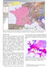
The Euratlas Periodis maps include 4 kind of entities - sovereign states, semi-independent states, provinces and autonomous peoples - and offer 2 display mode: 'Sovereign states' and 'Show dependencies'. By default, the display mode is set to 'Sovereign states' and the semi-independent states do not appear. They are incorporated in their dominant sovereign state. If you choose the 'Show dependencies' mode, by clicking somewhere on the main map or on a quarter-of-map link in Periodis Web, you will get an enlarged view and the semi-independent states will appear surrounded by a dotted line showing their dominant state. Note that, throughout history, there were countless legal or economic forms of dependency. By way of simplification we have put in the 'semi-independent' category, all the entities that were neither sovereign nor fully incorporated as mere provinces of a state, regardless to their nominal legal status.
1) Where is the Principality of Transylvania or Erdélyi Fejedelemség in the map of 1600 AD?
The prince of Wallachia Michael the Brave or Mihai Viteazu became overlord of Transylvania for nearly 1 year, from 1599 to 1600. One could argue that this overlordship was so short-lived that the 1600 map gives an erroneous vision of Transylvania political status. However that period was rather difficult for Transylvania because the principality was torn between the Habsburg Monarchy and the Ottoman Empire and the 1600 map shows one episode of these frictions. Moreover, this first political union of Transylvania and Wallachia is often regarded as a precusor of modern Romania.
2) In 1600 Wallachia included Moldavia; why do you show Moldavia as part of Poland-Lithuania?
Ieremia Movilă or Jeremi Mohyła was the ruler of Moldavia from 1595 until May 1600 under joint Polish-Ottoman overlordship. In May 1600, the prince of Wallachia Michael the Brave or Mihai Viteazu became prince of Moldavia. Thus the lands of Transylvania, Wallachia and Moldavia became united under the same ruler for nearly 6 months. The detailed Euratlas Periodis 1600 map shows the political situation in January 1600, so you will see Moldavia as a semi-independent Ottoman entity under Polish overlordship.
3) Since a vassal state was recognised as independent, therefore shouldn't it appear as an entity?
A vassal or semi-independent state is a political entity that has a defined territory with a population living on it and a ruling authority. However its authority is not supreme. It means that a higher authority - the 'owner' state in Euratlas Periodis - has the ability to take the most significant decisions like war and international relations. Since historical sources often rely on minor signs of power, like the ability to mint coins or to levy taxes or tributes, we have been compelled to classify in the 'semi-independent' category several entities that were nominally independent. In short, our main criterion is the ability to decide war and to have equal relations with a sovereign state. In consequence, as a matter of simplification, several medieval entities whose status was unclear have been drawn as semi-independent entities framed with a dotted line of their overlord, or owner, color.
4)The Romanian lands only paid tribute but never were a pashalic, why do you show them as parts of the ottoman Empire?
The name Romanian Lands or Danubian Principalities has been used since the Treaty of Kuchuk Kainarji (1774) to designate the principalities of Wallachia or Ţara Românească and of Moldavia or Moldova. From the 15th century, with interruptions until the 19th century, both entities came under Ottoman overlordship and remained autonomous except for foreign affairs.
5) Brittany or Bretagne was still an independent duchy until the 15th century; why don't you highlight it as such?
The Kingdom of France defeated the Breton army in 1488, and Duke Francis II was forced, through the Treaty of Sablé, to give the King of France the right to determine the marriage of the Duke's daughter, Anne of Brittany, heir to the Duchy. This put an end to the effective autonomy of Brittany while, nominally, it remained an 'independent' duchy until 1532. In this case the distinction between semi-independent entity and integrated French province is rather difficult. Both choices may have been possible. We have opted for the second one because, in the same map there is a real semi-independant powerful entity within the boundaries of France: the Kingdom of Navarre.
6) Why do you show Eastern Rumelia as part of the Ottoman Empire in the detailed map of 1900 and fully Bulgarian on the main map of 1900?
Since 1878, Eastern Rumelia was an autonomous province within the Ottoman Empire with a large majority of Bulgarian speaking population. In 1885, Eastern Rumelia was annexed by its neighbour, the Principality of Bulgaria, theoretically also an autonomous Ottoman province but effectively independent since 1878. The official independence of the unified Kingdom of Bulgaria was proclaimed in 1908. In the Periodis map 1900, if you choose the 'Sovereign states' mode, you will see the Principality of Bulgaria drawn as a sovereign state including Eastern Rumelia but if you switch to the 'Show dependencies' mode, Eastern Rumelia will appear as an Ottoman territory under the overlordship of Bulgaria.
7) Since Iraq is still a sovereign nation and a country of Kurdistan does not exist, why are you showing a country called Kurdistan in the northern part of Iraq in 2000?
In 1970, through an agreement between the government of Iraq and the Iraqi Kurdish community a Kurdish Autonomous Region was created with its capital at Arbil. After the First Gulf War in 1991, a northern no-fly zone was established to protect this region. On Periodis map 2000, with 'Show dependencies' mode on, you will notice that the Kurdistan region is shown as a semi-independent entity within the Republic of Iraq.
8) Why the 1900 map shows that the Ottoman Empire ruled over Tripoli and Egypt, since both were by that time ruled by Italy and England respectively?
In 1900, the territories of Tripoli, Ghadames, of al Khums and the Fezzan were constituting the Ottoman vilayet of 'Tripoli in Africa'. Benghazi was a separate vilayet, while the Senussi or Sanusiyah Brotherhood was controlling south Cyrenaica as a semi-independent power. The Italian colonization began in 1911.
Still in 1900, the Khedivate of Egypt was, nominally, an autonomous tributary state within the Ottoman Empire but, effectively, under British occupation. The Periodis map of Egypt 1900 is complicated to the same extent by this political situation. In 'Sovereign states' mode, Egypt appears as a British territory under Ottoman overlordship and in 'Show dependencies' mode, Egypt is an Ottoman territory under British overlordship.
See also the article
From Historical Mapping To Historical Geographical
Information System

PDF format
or the presentation

PDF format
Periodical Historical Atlas of Europe
according to your needs