Euratlas Home>
Historical Maps>
History of Europe>
Rhine-Oder Area
Fly over a highly detailed map of Europe in year 1200 and discover every polity
About
Privacy
Site Map
Contact
Rhine-Oder Area
Historical Maps
Geography Maps
Europe Atlas
World Atlas
Antique Maps
Antique Cartography
Lesage Atlas 1808
Peutinger Map
Europe Photos
Countries of Europe
Time Pictures
Euratlas
Shop
Europe 1200
Historical Maps
Middle East History
Roma
World History
History of Europe
Year 2000 A.D.
Year 1900 A.D.
Year 1800 A.D.
Year 1700 A.D.
Year 1600 A.D.
Year 1500 A.D.
Year 1400 A.D.
Year 1300 A.D.
Year 1200 A.D.
Year 1100 A.D.
Year 1000 A.D.
Year 900 A.D.
Year 800 A.D.
Year 700 A.D.
Year 600 A.D.
Year 500 A.D.
Year 400 A.D.
Year 300 A.D.
Year 200 A.D.
Year 100 A.D.
Year 1 A.D.
Explanation
Map Legend
Bibliography 1900
Detailed Maps
Aegean Area
Apennine Peninsula
Iberian Peninsula
Oder-Dnieper
Pyrénées-Rhine
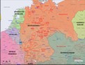
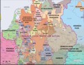
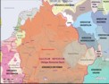
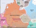
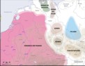
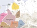
Rhine-Oder
Rhine-Rhône
Detailed Historical Maps of the Rhine-Oder Area
(7 images)
1900
1700
1500
1200
1000
800
600
Conditions of Use
Privacy Notice
Contact
Euratlas - 2001-2012