Euratlas Home>
Historical Maps>
History of Europe>
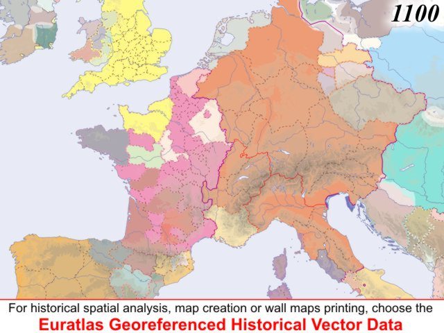
Europe 1100>
Europe 1100 Southwest
Become a member and get access to larger maps by subscribing to Euratlas-Info.
About
Privacy
Site Map
Contact
Europe 1100 Southwest
Historical Maps
Geography Maps
Europe Atlas
World Atlas
Antique Maps
Antique Cartography
Lesage Atlas 1808
Peutinger Map
Europe Photos
Countries of Europe
Time Pictures
Euratlas
Shop
Member's Area
Historical Maps
Middle East History
Roma
World History
History of Europe
Year 2000 A.D.
Year 1900 A.D.
Year 1800 A.D.
Year 1700 A.D.
Year 1600 A.D.
Year 1500 A.D.
Year 1400 A.D.
Year 1300 A.D.
Year 1200 A.D.
Year 1100 A.D.
Year 1000 A.D.
Year 900 A.D.
Year 800 A.D.
Year 700 A.D.
Year 600 A.D.
Year 500 A.D.
Year 400 A.D.
Year 300 A.D.
Year 200 A.D.
Year 100 A.D.
Year 1 A.D.
Explanation
Map Legend
Bibliography 1100
Detailed Maps
Aegean Area
Apennine Peninsula
Iberian Peninsula
Oder-Dnieper
Pyrénées-Rhine
Rhine-Oder
Rhine-Rhône
>
This map is in
Show Dependencies
mode
Map of Europe 1100 Southwest
Northwest
Northeast
Southwest
Southeast
Ahlat (S)
Cilician Armenia (D)
Keysun (D)
Pomerelia (S)
Ailech (S)
Connacht (S)
Khazars (S)
Powys (D)
Airgíalla (S)
Copnic (D)
Laighin (S)
Provence (D)
Alania (S)
Croatia (D)
Latvians (P)
Prussians (P)
Albarracín (D)
Cumans (P)
León-Castile (S)
Ragusa (S)
Aleppo (S)
Curonians (P)
Lithuanians (P)
Rana (S)
Almoravids (S)
Damascus (S)
Liutizians (S)
Raška (D)
Alpuente (D)
Danishmends (S)
Livonians (P)
Roman Empire (S)
Amalfi (S)
Deheubarth (D)
Lori (S)
Rostov-Suzdal (S)
Amida (S)
Denmark (S)
Lusatia (D)
Roussillon (D)
Ani (S)
Diocleia (S)
Lérida (D)
Rus Land (S)
Anjou (D)
Dunholm (D)
Mann and the Isles (D)
Rûm (S)
Antioch (S)
Dyflin (S)
Meissen (D)
Sason (S)
Apulia-Calabria (S)
Edessa (S)
Melitene (D)
Scotland (S)
Aquitaine (D)
Empire of the Romans (S)
Merseburg (D)
Scrobbesbyrigscir (D)
Aragon-Navarre (S)
England (S)
Mide (S)
Selonians (P)
Baghdad (S)
Erzinjan (S)
Moks (S)
Semigallians (P)
Balearic Islands (S)
Erzurum (S)
Moray (S)
Sicily (D)
Banu Hilal (S)
Fatimids (S)
Mordvins (P)
Smolensk (S)
Banu Jami (S)
Finns (P)
Mosul (S)
Strathclyde ? (D)
Banu Sulaym (S)
Flanders (D)
Mumhan (S)
Sudovians (P)
Barcelona (S)
Franks (S)
Mzab (S)
Sweden (S)
Besalú (D)
Friesland (D)
Naples (S)
Tortosa (D)
Blois-Champagne (D)
Galicja (S)
Norway (S)
Toulouse (D)
Bohemia (D)
Galloway (D)
Novgorod (S)
Travunia (D)
Bosnia (D)
Genoa (D)
Nájera-Pamplona (D)
Ulaidh (S)
Britanny (D)
Georgia (S)
Obotrites (S)
Valencia (S)
Burtas (P)
Gerger (D)
Oghuz (P)
Venice (S)
Béjaïa (S)
Glamorgan (D)
Papal States (S)
Vlachs (S)
Capua (D)
Gwynedd (S)
Pechenegs (P)
Zachlumia (D)
Cerdanya (D)
Henfordd (D)
Pereyaslav-Rus (S)
Zaragoza (D)
Cestrescir (D)
Hungary (S)
Pisa (S)
Zeitz (D)
Cheremiss (P)
Ifriqiya (S)
Poland (S)
Zhmuds (P)
Chernigov (S)
Jerusalem (S)
Polotsk (S)
Chudes (P)
Kars (S)
Pomerania (S)
Conditions of Use
Privacy Notice
Contact
Euratlas - 2001-2012